SHAPEFILE EXTRACTION IN SAP BODS STEPS
The shape file format can store the geometric location and
attribute information of geographic features. Geographic features in a
shape file can be represented by points, lines, or polygons (areas).


Mandatory files
- .shp — shape format; the feature geometry itself
- .shx — shape index format; a positional index of the feature geometry to allow seeking forwards and backwards quickly
- .dbf — attribute format; columnar
attributes for each shape
The
Shapefile adapter allows you to load the geospatial vector data from
Shapefiles into the any other database for further analysis.
|
Each Shapefile consists of one set of
.dbf, .shp, .prj and .shx files. If there are duplicates, they must be separated
into multiple sub-directories so that each file folder contains only one .dbf,
.shp, .prj and .shx file.
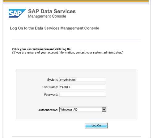
- Login to Data services management console http://etcvdsds303.na.cokecce.com:8090/
Please change the URL Accordingly based on Environment i.e. QA or PROD
- Under Administrator click on Adapter Instances
- Select a Job Server under the Adapter Instance

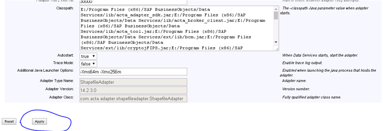
- Click on Adapter Configuration and Select Add
- On the next Screen select Shapefile Adapter
- On the form provide a proper Adapter Instance name. Rests of the fields are not mandatory.
- After filling in the required details click on Apply
- Now go back to Adapter Instances Status, select the Adapter Instance Name and click on Start
- After the Adapter is started properly it denotes Green check just before the Adapter Instance Name.
- Creating Data store for importing shape file, Shape files located in \\nasgfil3_1\sapbod_dev\OSD_TRP\ActualShapefiles , Declare $$OSD_TRP_SHAPE_ProcessingFilepath -> \\\\nasgfil3_1\\sapbod_dev\\OSD_TRP\\ProcessShapefiles\\
- Importing shape file through data store
- Shape file in Out folder
- Extracting shape files from \\nasgfil3_1\sapbod_dev\OSD_TRP\ActualShapefiles path
Comments
Post a Comment